
I had the opportunity to spend some time at Bear Mountain State Park in New York recently. It was a heck of an experience. Overall, I was reminded of how rugged East coast running is compared to the pleasant pine forest and mountain bike trails I am used to running. The state park itself is only about an hour away from NYC, so that makes it awesomely accessible for anyone who can get a cheap flight into NYC (spirit airlines anyone?). Sitting right on the Hudson river, most of the trails from the main parking lot that I had access to started at about 100 ft above sea level. Luckily I had been preparing for this trip in my altitude tent so I was ready the severely hypoxic conditions presented by these trails (thats a joke, sometimes sarcasm isnt so clear in text...). No really, it was awesome to know that I was basically starting all my runs at sea level, so any elevation indicated on my topographical map was directly correlated to verticle ascent. You can find a nice map of Bear Mountain park online, however, Bear Mountain is connected with another, larger park, called Harriman State Park, which was next to impossible to find a clear map of online. I bought maps (10$) at the park store so that I wouldnt be relying on trail markings.
 |
| Not the easiest trail to follow... |
The very first day I was there, I knew I wanted to summit Bear Mountain and then proceed on down the Appalachian Trail to see what I could see. There were two ways up to the summit, which included the AT or the Major Welch trail. My first trip up I made jumped on the Major Welch trail and was soon grunting may way up a steep incline. My run slowed, then turned to a powerhike, then I was hands on knees, forcing my way up. Then the trail disappeared and I was looking at exposed rock faces with little idea where I was supposed to go. UP, I thought, I am supposed to go up. After about 900 feet of climbing you come to an excellent view on a false summit. Here there were a few trail markers visible, so I was able to more easily navigate.
 |
| Started down by that there bridge |
Continuing up the Major Welch trail led to a quick summit after crossing a road. Here there were typical tourist amenities, bathrooms, a large parking lot, and a tower that must allow for a nice view. Everything was closed down, I am assuming because it was mid January and 14 degrees outside...
Speaking of 14 degrees, man was it cold and windy. I had to keep moving, otherwise I could feel myself start turning into a popsicle. Right near where the Major Welch trail emptied me out at, I saw the sign I had been looking for: AT this way! I excitedly began down the path. Soon I was looking at a sign directing me either South to Georgia or North to Maine. I went South. for the next mile or so I was descending, mostly by a rock staircase cut into the side of the mountain. This dumped out onto a gravel path, that was a continuation of the AT. Finally, some room to run. But this didnt last long as soon I was staring down at the ground, jumping through massive rock gardens. Being the first day, I decided I didnt want to get lost, and found the trail that took me off the AT and back towards the parking lot. It was hard to not continue South on the AT, but it was only the first day. 1777W trail was a ski trail that was quite a bit more open than the AT and I could finally put in some running. I did stop occasionally to take in the sites. One of the really cool things about the timing of my trip was that all the waterfalls were frozen into giant icicle sculptures. I ended up back at the parking lot earlier than I planned, so I decided to try a different trail to ascend Bear Mountain. This time I took the AT up, and it was MUCH easier (more gradual with better footing) and I ran almost the entire way. Then I tried to descend via the Major Welch trail, and found myself very thankful for the sticky rubber on the bottoms of the MT110. Running down the sheer rock faces at a 12-18% decline felt stupid dangerous, especially because I was armed with the knowledge that there was no good footing along the trail at all. But... I did it anyways. At the end of the trail my legs were shaking, and I dont know if it was from fatigue from the steep decline or adrenaline, but again, super thankful for the sticky rubber.
 |
| Frozen water. Falling. |
The next day I decided I wanted to go further into the park and explore the running possibilities of other trails. Knowing that the AT provided a fast and fun ascent of Bear Mountain, we quickly tagged the summit, then proceeded back down the stone stairs and into the park. This time, I did not take the 1777W ski trail and continued along the AT. Some of the running was fast, but most of it consisted of rock gardens and boulders. I saw the occasional backpacker, but mostly was alone to enjoy the sites and sounds. After climbing for a while, I found myself on top of West Mountain, overlooking the park. Another great view. Somehow here, I became turned around and did a small extra loop between the AT and the Ramapo-Dunderberg trail. It wasn't a long loop (distance wise), but it was NOT runnable. I found myself at a scenic view known as Cats Elbow (??) and was lowering myself down over boulders for a good 10 minutes, before running 10 minutes and having to climb back up the same elevation and worse terrain. Some of it was dangerously coated with ice, but if I was careful I managed not to fall. Back on my planned route, I took the Sufferin Bear Mountain trail down into Doodletown (a historic site from the late 1700s) and passed an old mine and cemetary. The descent down teh SBM trail was extremely hairy, and again found myself running downhills slower than the uphills. It was a giant rock garden with a mostly frozen river meandering through it, was the occasional yellow swath painted on a tree. I had to stop numerous times and search for the next tree with a marking and then go forward. * When I got home I looked up TNF50 mile run route, and it stated that this section was the most difficult part of the race (and I believe it).
 |
| Did I mention it was icy? |
The rest of my run was very enjoyable. I ran into another couple trail runners, we chatted for a while, and then I pushed on down the home stretch. I was amazed to look at my GPS later in the night and realize that in 3 hours I had barely covered 12 miles, but had accumulated 3000 feet of verticle and an equal amount of decent. When thinking about TNF 50 mile @ Bear Mountain, I had to look up the course map and compare it to my days. Overall, TNF doesnt summit Bear Mountain, I assume this is because the AT is off-limits, and the Major Welch trail is too treacherous for a race. I saw numbers suggesting there was a total of 7000-8000 feet of climbing in the 50 mile race, and I believe it. It did occur to me that if I had accumulated 50 miles during my runs, I would have racked up 15,000 feet of climbing. This made me happy, despite the less then satisfying mileage totals. Quality over quantity, right? Also looking at TNF trail map, I found that the race does a wonderfully long single loop circumnavigation of the Bear Mountain and Harriman State parks. Someday I would really like to give this race a try. Next time I am back at this park I will try to stick to some of the trails that the race itself travels as well as the sky trails, in order to get an idea of what the race is like, because right now I am more than slightly intimidated. More impressive than intimidating is Jennifer Pharr-Davis' recent long trail record on the AT through hike. After spending a couple days on this trail, I can only think how determined, tough, and incredible the people who do this through hike must be.
 |
| Sticky rubber helps |
If anyone is ever planning a trail running trip to this park and wants to know what routes I took, or any other details feel free to leave me a comment.
 |
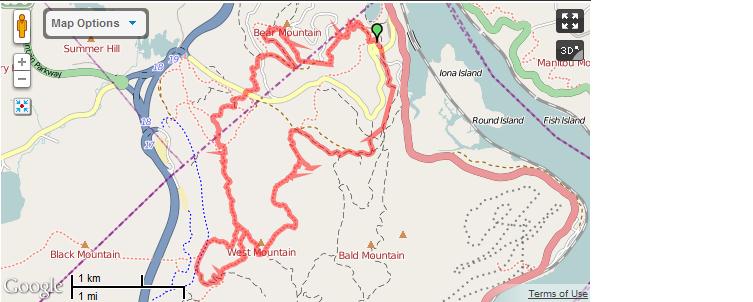
| Day 1 - 2500 feet ascent |
 |
| Day 2 - 3000 feet ascent |


Great article, glad to hear your thoughts on east coast running, I'm from CT and it's cool to hear. The shenipsit trail in CT (http://en.wikipedia.org/wiki/Shenipsit_Trail) is 41 miles long, it's crazy to think that to you, that's just an average run, while to me, completing that length would be a lifetime achievement!
ReplyDeleteHey rob, haha I still dont think 41 miles is what I would call an average run... Maybe if I find myself in the area I will check out the Shenipsit. East coast running was amazingly hard. Harder than the running I experienced when I was out in Rocky Mountain National Park and Breckinridge in Co. Mostly due to the incredibly technical nature.
Delete